Osaka to Nagoya
Tuesday, Nov. 15, 2022
 |
| Entry way to the Hotel Nikko where we spent the night. |
We went out looking for breakfast and found "Tasty Street" in the airport but everything was still closed.
We asked an ANA representative where we could get breakfast and..... she sent us to -----McDonalds!!!
 |
| GHB, forever on his phone, as we have a cup of coffee at McDonalds. It is always good to try the local cuisine when one is traveling in a foreign country! |
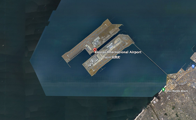
Kansai International Airport is on a man made island and has every convenience possible right at the airport.
 |
| We spent the night near the Kansai International Airport. |
We are going to take the train from Osaka to Nagoya which involves taking the JR line from Kansai to Shin Osaka (main train station in Osaka) and then catching the Shinkansen to Nagoya Station.
 |
| The route from Kansai Airport to Nagoya /// with a train change in Shin Osaka. |
Larry Crowder texted GHB this morning that he had arrived in Nagoya and we will get together later when we get to Kanayama, Nagoya.
We made it to Kaniyama at 1500 h Japan time.. Went from Kansai to Shin osaka- $23, from Shin Osaka to Nagoya Station ($45) and then from Nagoya station to Kaniyama... no charge. Total travel time, with being lost several times and wandering around Shin Osaka and Nagoya station for a while, was about 4.5 hours.
 |
| When we finally got to Kaniyama Station it was almost like coming home we have been here so many times in the past to deploy satellite tags on juvenile loggerheads. |
We are now in our hotel at Ana Crown Plaza Kaniyama and can't wait to meet up with our friends Masanori and Tomomi.
ABOUT MAPPING
As our project gets underway, we have been contemplating how to create a website that will be engaging and informative to the general public and yet exciting and interesting to the science nerd / professional. We are interested in looking into the service provided by Wildlife Computers to construct web based maps of tracks like the one shown below of Southern Hemisphere albatrosses.
Looks interesting - continuing to investigate.
I will note that this map of the tracks looks to be a .kml file uploaded to Google Earth. I have been doing this with our Vauatu data using Zoatrack.org for some time now... see below.
 |
| The tracks of the two post-nesting hawkbills as uploaded from Zoatrack to google earth as a .kml file. These tracks can also be anmated. |


Comments
Post a Comment